As a local in Teton County, we have all been asked the same question when we are out and about in Grand Teton National Park – which mountain is that one?
This summer the National Park Service celebrates its 100th anniversary and we are expecting over 5 million people to visit the valley. Because you will undoubtedly be asked this question over and over again, here’s a quick overview of the Teton Mountain Range.
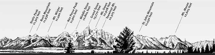
First – there is only one mountain called the Grand Teton in the Teton Range. We’ll let most people slide on this one!
The Grand Teton is the highest point in the Teton Range at 13,775 feet and the second highest peak in the U.S. state of Wyoming after Gannett Peak. While the origin of the name is disputed, the most common explanation is that Grand Teton means large teat in French, named by either French-Canadian or Iroquois members of an expedition led by Donald McKenzie of the North West Company.
Along with the name disagreement, there is also disagreement in who first climbed the Grand. Nathaniel Langford and James Stevenson claimed to have reached the summit on July 29, 1872. Other firsts include:
· First Male Alpine Descent-Bill Briggs, 1971
· First Female Alpine Descent- Kristen Ulmer, 1997
· First Male Telemark Descent- Rick Wyatt, 1982
· First Female Telemark Descent- A.J. Cargill, 2004
· First Male Snowboard Descent- Stephen Koch, 1989
· First Female Snowboard Descent- Dani deRuyter, 2010
Mt. Owen is the second highest peak in the Teton Range at 12,928 feet. William O. Owen who the peaked is named after, organized the first documented ascent of the of the Grand Teton in 1898.
Teewinot Mountain’s name was derived from the Shoshone Native American word meaning “many pinnacles.” At 12,330 feet it is the sixth highest peak in the Teton Range. The peak is northeast of the Grand Teton. Broken Falls is one of the tallest cascades in Grand Teton National Park and descends 300 feet down the eastern slopes of Teewinot Mountain.
Mt. Saint John is located on the north end of the Teton Range at 11,430 feet. The mountain towers above the northwest shore of Jenny Lake along with Symmetry Spire and Rockchuck Reak on the north side of Cascade Canyon. You’ll find the scenic Lake of the Crags just south of the summit and is accessed by way of Hanging Canyon.
Mt. Moran was named for Thomas Moran, an American western frontier landscape artist. At 12,605 feet, Mt. Moran sits at the backdrop to Jackson Lake. It has a very distinctive basalt line running up its face called the Black Dike.
Mt. Moran is a very difficult, technical climb and the first ascent was made on July 22, 1922 by LeGrand hardy, Bennet McNulty and Ben Rich of the Chicago Mountaineering Club.
On November 12, 1950, a C-47 cargo plane crashed on Mt. Moran killing all 21 on board. While a rescue party was organized, the location of the crash made it impossible to recover the plane or the bodies. The wreckage remains on the mountain today, but the Park Service discourages direct climbs to the site.
Middle Teton is immediately southwest of the Grand and is 12,804 feet, the third highest peak. The first recorded ascent of Middle Teton was by Albert R. Ellingwood on August 23, 1923.
Nez Perce Peak is immediately southeast of Grand Teton and considered to be part of the Cathedral Group. Nez Perce is a dramatic peak that dominates the skyline to the west of Bradley and Taggart Lakes. When viewed from the western section of Jackson Hole, Nez Perce often obscures the view of Cloudveil Dome as well as South Teton, even though both summits are higher.
South Teton is 12,514 feet and south of the Middle Teton. The South Teton was also first climbed by Albert R. Ellingwood ad Eleanor Davis on August 29th, 1923. Davis was the first woman to ascend the Grand Teton.
Mt. Wister was named for Owen Wister, an early visitor to the Jackson area. The mountain which is 5 miles west of Taggart Lake was first climbed by Phil Smith in 1928. It is 11,495 feet high.
Buck Mountain is an excellent location for views of the Cathedral Group to the north. At 11,938 feet, the west slope of the summit tower are along the Alaska Basin Trail and extend into the Caribou-Targhee National Forest and the Jedediah Smith Wilderness which is a popular camping area for backpackers. The summit was first climbed on August 21, 1898 by T.M. Bannon and George Buck.
Static Peak is 11,303 feet and is located south of Buck Mountain. The summit can be climbed in a scramble. Below the summit on the north face is a small glacier sheltered from direct sunlight by steep cliffs. Timberline Lake lies to the north of the peak. |